
Make a donation
Gear up for your next adventure:
As an Amazon Associate, this site earns from qualifying purchases at no extra cost to you.
O Canizo topographic map
Click on the map to display elevation.
Make a donation
Gear up for your next adventure:
As an Amazon Associate, this site earns from qualifying purchases at no extra cost to you.
About this map
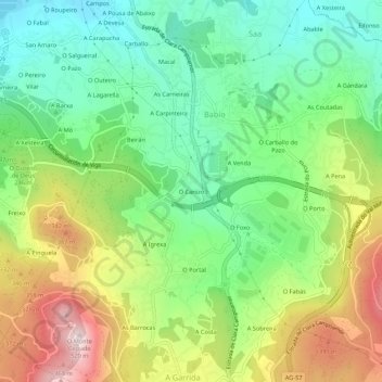
Name: O Canizo topographic map, elevation, terrain.
Location: O Canizo, Valadares, Vigo, Pontevedra, Galicia, 36314, España (42.16526 -8.73860 42.20526 -8.69860)
Average elevation: 669 ft
Minimum elevation: 46 ft
Maximum elevation: 1,683 ft
Make a donation
Gear up for your next adventure:
As an Amazon Associate, this site earns from qualifying purchases at no extra cost to you.
Other topographic maps
Click on a map to view its topography, its elevation and its terrain.
Make a donation
Gear up for your next adventure:
As an Amazon Associate, this site earns from qualifying purchases at no extra cost to you.
Parque Nacional Marítimo Terrestre de las Islas Atlánticas de Galicia
España > Galicia > Vigo > Vigo
Average elevation: 154 ft
Make a donation
Gear up for your next adventure:
As an Amazon Associate, this site earns from qualifying purchases at no extra cost to you.