
Jamwa Ramgarh topographic map
Interactive map
Click on the map to display elevation.
About this map
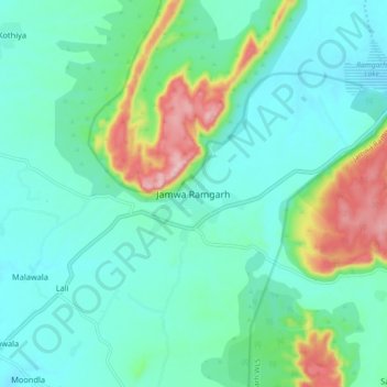
Name: Jamwa Ramgarh topographic map, elevation, terrain.
Location: Jamwa Ramgarh, Jamwa Ramgarh Tehsil, Jaipur, Rajasthan, India (26.98290 75.97004 27.06290 76.05004)
Average elevation: 1,411 ft
Minimum elevation: 1,220 ft
Maximum elevation: 2,047 ft
Other topographic maps
Click on a map to view its topography, its elevation and its terrain.
Balod
India > Rajasthan > Jamwa Ramgarh Tehsil
Balod, Jamwa Ramgarh Tehsil, Jaipur District, Rajasthan, India
Average elevation: 1,460 ft
Jamwa Ramgarh WLS
India > Rajasthan > Jamwa Ramgarh Tehsil
Jamwa Ramgarh WLS, Jamwa Ramgarh Tehsil, Jaipur, Rajasthan, 303109, India
Average elevation: 1,365 ft
Basna
India > Rajasthan > Jamwa Ramgarh Tehsil > Basna
Basna, Jamwa Ramgarh Tehsil, Jaipur, Rajasthan, 303120, India
Average elevation: 1,421 ft