
Make a donation
Gear up for your next adventure:
As an Amazon Associate, this site earns from qualifying purchases at no extra cost to you.
Ophoven topographic map
Click on the map to display elevation.
Make a donation
Gear up for your next adventure:
As an Amazon Associate, this site earns from qualifying purchases at no extra cost to you.
Ophoven
Ophoven ligt aan de rand van een holocene vlakte, de Maasvallei, waarover de Maas meanderde gedurende het Holoceen. De rand van de vallei is een steilrand (het Maastalud) van enkele meters hoogte, die de overgang vormt naar het middenterras van de Maas. Hierlangs liep de voormalige Romeinse heerbaan. De vallei was vruchtbaar, maar werd regelmatig overstroomd. Hier lagen ooit een aantal hoeven, een watermolen en dergelijke. Eind 17e eeuw verdween de bewoning, nadat enkele grote overstromingen hadden plaatsgevonden. Vanaf 1944 werd het gebied vergraven ten behoeve van de grindwinning, waarbij grote waterplassen ontstonden. Deze werden omgevormd tot watersportrecreatiegebied, zie De Spaanjerd.
Make a donation
Gear up for your next adventure:
As an Amazon Associate, this site earns from qualifying purchases at no extra cost to you.
About this map
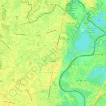
Name: Ophoven topographic map, elevation, terrain.
Location: Ophoven, Kinrooi, Maaseik, Limburg, België (51.11986 5.73773 51.14465 5.84485)
Average elevation: 95 ft
Minimum elevation: 52 ft
Maximum elevation: 118 ft
Make a donation
Gear up for your next adventure:
As an Amazon Associate, this site earns from qualifying purchases at no extra cost to you.
Other topographic maps
Click on a map to view its topography, its elevation and its terrain.
Make a donation
Gear up for your next adventure:
As an Amazon Associate, this site earns from qualifying purchases at no extra cost to you.