
Make a donation
Gear up for your next adventure:
As an Amazon Associate, this site earns from qualifying purchases at no extra cost to you.
Navarrete topographic map
Click on the map to display elevation.
Make a donation
Gear up for your next adventure:
As an Amazon Associate, this site earns from qualifying purchases at no extra cost to you.
Navarrete
À 11 km est de Logroño, à 512 m d’altitude, le point culminant est à 781 m, au Cerro de la Dehesa.
Make a donation
Gear up for your next adventure:
As an Amazon Associate, this site earns from qualifying purchases at no extra cost to you.
About this map
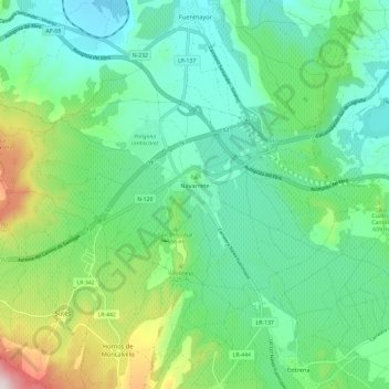
Name: Navarrete topographic map, elevation, terrain.
Location: Navarrete, La Rioja, Espagne (42.40541 -2.62369 42.44852 -2.50502)
Average elevation: 1,785 ft
Minimum elevation: 1,299 ft
Maximum elevation: 3,166 ft
Make a donation
Gear up for your next adventure:
As an Amazon Associate, this site earns from qualifying purchases at no extra cost to you.
Other topographic maps
Click on a map to view its topography, its elevation and its terrain.
Make a donation
Gear up for your next adventure:
As an Amazon Associate, this site earns from qualifying purchases at no extra cost to you.