
Union Grove topographic map
Click on the map to display elevation.
Union Grove
Union Grove is located in western Marshall County at 34°24′0″N 86°26′46″W / 34.40000°N 86.44611°W / 34.40000; -86.44611 (34.400088, -86.446049). It is 7 miles (11 km) northeast of Arab and 5 miles (8 km) southwest of Guntersville Dam on the Tennessee River. Union Grove sits at an elevation of 1,040 feet (320 m) above sea level on the relatively flat top of Brindley Mountain, near the southwest end of the Appalachian Plateau. Electricity service in Union Grove is provided through Arab Electric Cooperative, which comes through the Tennessee Valley Authority.
About this map
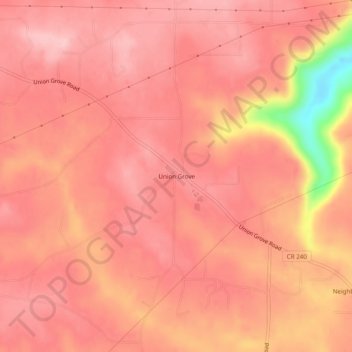
Name: Union Grove topographic map, elevation, terrain.
Location: Union Grove, Marshall County, Alabama, United States (34.38176 -86.46915 34.42176 -86.42915)
Average elevation: 984 ft
Minimum elevation: 558 ft
Maximum elevation: 1,099 ft
Marshall County trails, hiking, mountain biking, running and outdoor activities