Geolocate

Tactac topographic map

Click on the map to display elevation.

About this map

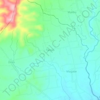
Name: Tactac topographic map, elevation, terrain.

Location: Tactac, Balayan, Batangas, Calabarzon, 4214, Philippines (13.96053 120.67747 14.00053 120.71747)

Average elevation: 187 ft

Minimum elevation: 43 ft

Maximum elevation: 656 ft

Other topographic maps

Click on a map to view its topography, its elevation and its terrain.

Balayan Baywalk Park

Philippines > Batangas > Balayan > San Juan

Average elevation: 16 ft

Gear up for your next adventure:

🏕️Family Camping Gear - Essentials for group camping trips
🪶Survival Guide Book - Expert advice for emergency preparedness
GPS Sports Watch - GPS watch for running, hiking and training
📱Heavy-Duty Phone Cases - Drop-proof and waterproof protection for outdoor navigation
🧭Compass with Lanyard - Easy‑carry compass for navigation

As an Amazon Associate, this site earns from qualifying purchases at no extra cost to you.