
Make a donation
Gear up for your next adventure:
As an Amazon Associate, this site earns from qualifying purchases at no extra cost to you.
Matagne-la-Grande topographic map
Click on the map to display elevation.
Make a donation
Gear up for your next adventure:
As an Amazon Associate, this site earns from qualifying purchases at no extra cost to you.
About this map
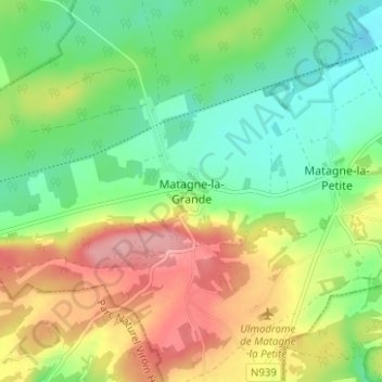
Name: Matagne-la-Grande topographic map, elevation, terrain.
Average elevation: 682 ft
Minimum elevation: 525 ft
Maximum elevation: 912 ft
Make a donation
Gear up for your next adventure:
As an Amazon Associate, this site earns from qualifying purchases at no extra cost to you.
Other topographic maps
Click on a map to view its topography, its elevation and its terrain.
Walcourt
België > Namen > Philippeville
Ieder jaar vindt hier de beroemde Grand Tour plaats, een processie ter ere van Onze-Lieve-Vrouw van Walcourt, waarbij het beeld wordt geëscorteerd door schutters in uniformen uit de napoleontische tijd. Deze Marche de la Trinité is een van de vijftien folkloristische stoeten van de Marches de…
Average elevation: 715 ft
Make a donation
Gear up for your next adventure:
As an Amazon Associate, this site earns from qualifying purchases at no extra cost to you.
Make a donation
Gear up for your next adventure:
As an Amazon Associate, this site earns from qualifying purchases at no extra cost to you.
Philippeville
België > Namen > Philippeville
Philippeville is een stad in de Belgische provincie Namen, aan de noordkant van de Fagne. De stad telt ruim 9000 inwoners en ligt op een hoogte van 269 meter.
Average elevation: 751 ft
Make a donation
Gear up for your next adventure:
As an Amazon Associate, this site earns from qualifying purchases at no extra cost to you.
Make a donation
Gear up for your next adventure:
As an Amazon Associate, this site earns from qualifying purchases at no extra cost to you.
Make a donation
Gear up for your next adventure:
As an Amazon Associate, this site earns from qualifying purchases at no extra cost to you.
Carrière de la Rochefontaine
België > Namen > Philippeville > Philippeville > Franchimont
Average elevation: 781 ft
Make a donation
Gear up for your next adventure:
As an Amazon Associate, this site earns from qualifying purchases at no extra cost to you.
Oignies-en-Thiérache
België > Namen > Philippeville
Het hoogste punt van België ten westen van de Maas is gelegen in de bossen ten zuidwesten van Oignies. Het reliëf bereikt er ongeveer 400 meter hoogte. In de Franse Ardennen ten zuiden van Oignies zijn er nog enkele hogere punten vooraleer het reliëf er daalt.
Average elevation: 1,040 ft
Florennes
België > Namen > Philippeville
Florennes ligt aan de Ruisseau d'Yves. De hoogte aan de kerk bedraagt 260 meter.
Average elevation: 823 ft
Make a donation
Gear up for your next adventure:
As an Amazon Associate, this site earns from qualifying purchases at no extra cost to you.
Make a donation
Gear up for your next adventure:
As an Amazon Associate, this site earns from qualifying purchases at no extra cost to you.