
Christopher topographic map
Click on the map to display elevation.
About this map
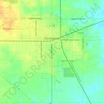
Name: Christopher topographic map, elevation, terrain.
Location: Christopher, Franklin County, Illinois, 62822, United States (37.95400 -89.07863 37.98141 -89.03230)
Average elevation: 427 ft
Minimum elevation: 381 ft
Maximum elevation: 476 ft
Franklin County trails, hiking, mountain biking, running and outdoor activities
Other topographic maps
Click on a map to view its topography, its elevation and its terrain.
West Frankfort
United States > Illinois > Franklin County
The area of West Frankfort formerly known as Frankfort is still sometimes referred to locally as Frankfort Heights or, more commonly, simply as "The Heights", due to its higher elevation relative to the rest of the city. A post office was maintained in Frankfort Heights until its destruction by fire in 2004,…
Average elevation: 400 ft