
Make a donation
Gear up for your next adventure:
As an Amazon Associate, this site earns from qualifying purchases at no extra cost to you.
Norris City topographic map
Click on the map to display elevation.
Make a donation
Gear up for your next adventure:
As an Amazon Associate, this site earns from qualifying purchases at no extra cost to you.
Norris City
The book, “Illinois, a Descriptive and Historical Guide,” compiled in 1939 by Federal Works Agency, Works Project Administration, states that Norris City, altitude 444, population 1109, a trading center for an agricultural and coal mining district was named in honor of a pioneer settler, William Norris. A reference report of the Illinois State Historical Library states, “No information is available in our records as to the origins of the name, Norris City.”
Make a donation
Gear up for your next adventure:
As an Amazon Associate, this site earns from qualifying purchases at no extra cost to you.
About this map
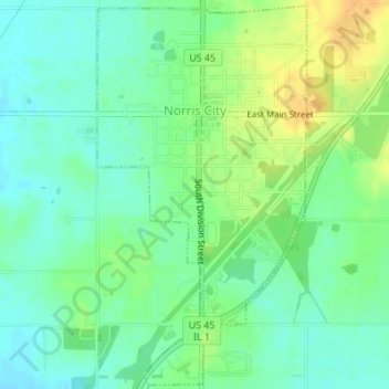
Name: Norris City topographic map, elevation, terrain.
Location: Norris City, White County, Illinois, United States (37.96207 -88.33785 37.98840 -88.31938)
Average elevation: 420 ft
Minimum elevation: 381 ft
Maximum elevation: 479 ft
White County trails, hiking, mountain biking, running and outdoor activities
Make a donation
Gear up for your next adventure:
As an Amazon Associate, this site earns from qualifying purchases at no extra cost to you.
Other topographic maps
Click on a map to view its topography, its elevation and its terrain.