
Make a donation
Gear up for your next adventure:
As an Amazon Associate, this site earns from qualifying purchases at no extra cost to you.
Lüsberg topographic map
Click on the map to display elevation.
Make a donation
Gear up for your next adventure:
As an Amazon Associate, this site earns from qualifying purchases at no extra cost to you.
About this map
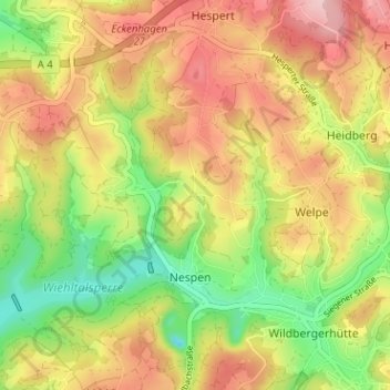
Name: Lüsberg topographic map, elevation, terrain.
Average elevation: 1,211 ft
Minimum elevation: 896 ft
Maximum elevation: 1,509 ft
Make a donation
Gear up for your next adventure:
As an Amazon Associate, this site earns from qualifying purchases at no extra cost to you.
Other topographic maps
Click on a map to view its topography, its elevation and its terrain.
Wiehltalsperre
Deutschland > Nordrhein-Westfalen > Oberbergischer Kreis > Reichshof > Nespen
Der Staudamm bei Ufersmühle staut das Wasser der Wiehl bis auf eine Höhe von 292,5 m ü. NN (Normalstau) bzw. 293,11 m ü. NN (Höchststau). Es handelt sich um einen Steinschüttdamm mit innen liegender Asphaltbetondichtung. Mit dem Talsperrenwasser aus der Wiehltalsperre und aus der Genkeltalsperre stellt…
Average elevation: 1,188 ft