
Kalasa topographic map
Click on the map to display elevation.
About this map
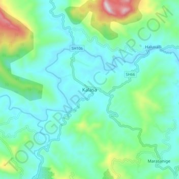
Name: Kalasa topographic map, elevation, terrain.
Location: Kalasa, Kalasa taluk, Chikkamagaluru, Karnataka, 577124, India (13.19222 75.31824 13.27222 75.39824)
Average elevation: 2,943 ft
Minimum elevation: 2,451 ft
Maximum elevation: 4,747 ft
Other topographic maps
Click on a map to view its topography, its elevation and its terrain.
Kudremukh National Park
India > Karnataka > Kalasa taluk
The park is adjoining to Someshwara Wildlife Sanctuary on the western side and is linked to Pushpagiri Wildlife Sanctuary through a narrow stretch of Reserved Forests on the southern edge. The southern & western sides of the Park form the steep slope of the Western Ghat ridge line, with the altitude varying…
Average elevation: 1,627 ft