Geolocate

Pischiv Rural Hromada topographic map

Click on the map to display elevation.

About this map

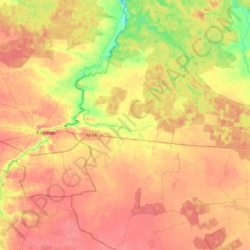
Name: Pischiv Rural Hromada topographic map, elevation, terrain.

Location: Pischiv Rural Hromada, Zviahel Raion, Zhytomyr Oblast, Ukraine (50.51311 27.18642 50.73888 27.37687)

Average elevation: 696 ft

Minimum elevation: 584 ft

Maximum elevation: 761 ft

Other topographic maps

Click on a map to view its topography, its elevation and its terrain.

Brusyliv

Ukraine > Zhytomyr Oblast

Average elevation: 574 ft

Teterivka

Ukraine > Zhytomyr Oblast

Average elevation: 676 ft

Perliavka

Ukraine > Zhytomyr Oblast

Average elevation: 686 ft

Marynivka

Ukraine > Zhytomyr Oblast > Marynivka

Average elevation: 715 ft

Novaky

Ukraine > Zhytomyr Oblast > Novaky

Average elevation: 584 ft

Gear up for your next adventure:

Backpacking Tents - Weight-optimized shelters for multi-day topographic surveys
🧦Hiking Socks - Comfortable socks to prevent blisters on long hikes
👟Trail Running Shoes - Lightweight shoes for trail runners
🥾Women's Hiking Boots - Top-rated trail boots with ankle support and superior grip
🌡️Handheld Weather Meters - Measure wind, temp, and pressure for safe mountain travel

As an Amazon Associate, this site earns from qualifying purchases at no extra cost to you.