Geolocate

Spring Mills topographic map

Click on the map to display elevation.

About this map

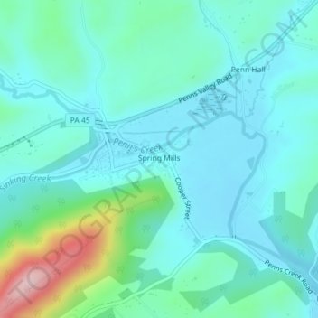
Name: Spring Mills topographic map, elevation, terrain.

Location: Spring Mills, Gregg Township, Centre County, Pennsylvania, United States (40.84628 -77.57532 40.86033 -77.55591)

Average elevation: 1,207 ft

Minimum elevation: 1,050 ft

Maximum elevation: 1,880 ft

Centre County trails, hiking, mountain biking, running and outdoor activities

Other topographic maps

Click on a map to view its topography, its elevation and its terrain.

New Town

United States > Pennsylvania > Centre County

Average elevation: 1,624 ft

Beech Creek

United States > Pennsylvania > Centre County

Average elevation: 1,476 ft

Buffalo Run

United States > Pennsylvania > Centre County

Average elevation: 1,342 ft

Bear Rocks

United States > Pennsylvania > Centre County

Average elevation: 2,060 ft

Milheim Narrows

United States > Pennsylvania > Centre County

Average elevation: 1,440 ft

Mingoville

United States > Pennsylvania > Centre County

Average elevation: 1,204 ft

Orviston

United States > Pennsylvania > Centre County

Average elevation: 1,332 ft

Peru

United States > Pennsylvania > Centre County

Average elevation: 1,175 ft

Potters Mills

United States > Pennsylvania > Centre County

Average elevation: 1,414 ft

Mount Eagle

United States > Pennsylvania > Centre County

Average elevation: 951 ft

Moshannon

United States > Pennsylvania > Centre County

Average elevation: 1,522 ft

Snydertown

United States > Pennsylvania > Centre County

Average elevation: 1,047 ft

Gear up for your next adventure:

⛑️Personal Locator Beacon - Safety beacon for emergencies
🚑Emergency Bivvies - Heat-reflective sleeping bags for survival situations
💧Water Purification System - Clean water on the trail with reliable purifiers
🚪Portable Camp Chair - Foldable chair for comfort at camp
📖Nature Tracking Books - Learn to track wildlife and terrain

As an Amazon Associate, this site earns from qualifying purchases at no extra cost to you.