
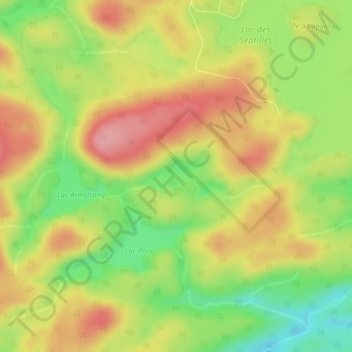
Lac des Îles topographic map
Interactive map
Click on the map to display elevation.
About this map
Name: Lac des Îles topographic map, elevation, terrain.
Average elevation: 390 ft
Minimum elevation: 180 ft
Maximum elevation: 574 ft
Other topographic maps
Click on a map to view its topography, its elevation and its terrain.
Saint-François-de-Pabos
Canada > Quebec > Le Rocher-Percé > Chandler
Saint-François-de-Pabos, Chandler, Le Rocher-Percé, Gaspésie–Îles-de-la-Madeleine, Quebec, G0C 2H0, Canada
Average elevation: 135 ft
Newport-Ouest
Canada > Quebec > Le Rocher-Percé > Chandler
Newport-Ouest, Chandler, Le Rocher-Percé, Gaspésie–Îles-de-la-Madeleine, Quebec, G0C 2A0, Canada
Average elevation: 125 ft
Île Beau Séjour
Canada > Quebec > Le Rocher-Percé > Chandler
Île Beau Séjour, Chandler, Le Rocher-Percé, Gaspésie–Îles-de-la-Madeleine, Quebec, Canada
Average elevation: 7 ft
Pabos
Canada > Quebec > Le Rocher-Percé > Chandler
Pabos, Chandler, Le Rocher-Percé, Gaspésie–Îles-de-la-Madeleine, Quebec, G0C 2H0, Canada
Average elevation: 30 ft