
Make a donation
Gear up for your next adventure:
As an Amazon Associate, this site earns from qualifying purchases at no extra cost to you.
Dodgeville topographic map
Click on the map to display elevation.
Make a donation
Gear up for your next adventure:
As an Amazon Associate, this site earns from qualifying purchases at no extra cost to you.
About this map
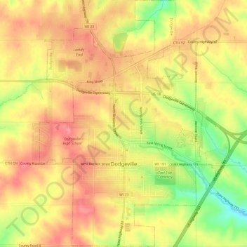
Name: Dodgeville topographic map, elevation, terrain.
Location: Dodgeville, Iowa County, Wisconsin, United States (42.94524 -90.15090 42.98898 -90.10826)
Average elevation: 1,211 ft
Minimum elevation: 1,033 ft
Maximum elevation: 1,316 ft
Iowa County trails, hiking, mountain biking, running and outdoor activities
Make a donation
Gear up for your next adventure:
As an Amazon Associate, this site earns from qualifying purchases at no extra cost to you.
Other topographic maps
Click on a map to view its topography, its elevation and its terrain.
Blue Mound State Park
United States > Wisconsin > Iowa County > Town of Brigham
Average elevation: 1,365 ft
Governor Dodge State Park
United States > Wisconsin > Iowa County > Town of Dodgeville
Average elevation: 1,102 ft
Tower Hill State Park
United States > Wisconsin > Iowa County > Spring Green
Average elevation: 764 ft