
Thank you for supporting this site ❤️
Make a donation
Make a donation
Gear up for your next adventure:
As an Amazon Associate, this site earns from qualifying purchases at no extra cost to you.
Bowman topographic map
Click on the map to display elevation.
Thank you for supporting this site ❤️
Make a donation
Make a donation
Gear up for your next adventure:
As an Amazon Associate, this site earns from qualifying purchases at no extra cost to you.
About this map
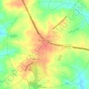
Name: Bowman topographic map, elevation, terrain.
Location: Bowman, Elbert County, Georgia, 30624, United States (34.19050 -83.04440 34.21674 -83.01302)
Average elevation: 732 ft
Minimum elevation: 643 ft
Maximum elevation: 801 ft
Thank you for supporting this site ❤️
Make a donation
Make a donation
Gear up for your next adventure:
As an Amazon Associate, this site earns from qualifying purchases at no extra cost to you.
Other topographic maps
Click on a map to view its topography, its elevation and its terrain.
Elberton County Memorial Park
United States > Georgia > Elbert County > Elberton
Average elevation: 659 ft