
Make a donation
Gear up for your next adventure:
As an Amazon Associate, this site earns from qualifying purchases at no extra cost to you.
Kinston topographic map
Click on the map to display elevation.
Make a donation
Gear up for your next adventure:
As an Amazon Associate, this site earns from qualifying purchases at no extra cost to you.
About this map
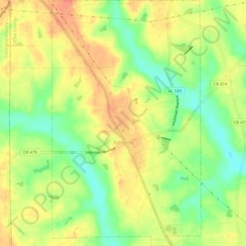
Name: Kinston topographic map, elevation, terrain.
Location: Kinston, Coffee County, Alabama, 36453, United States (31.19828 -86.18534 31.24038 -86.15542)
Average elevation: 236 ft
Minimum elevation: 148 ft
Maximum elevation: 308 ft
Coffee County trails, hiking, mountain biking, running and outdoor activities
Make a donation
Gear up for your next adventure:
As an Amazon Associate, this site earns from qualifying purchases at no extra cost to you.
Other topographic maps
Click on a map to view its topography, its elevation and its terrain.
Indian Springs
United States > Alabama > Coffee County > Enterprise > Indian Springs
Average elevation: 315 ft
Valley Hills
United States > Alabama > Coffee County > Enterprise > Valley Hills
Average elevation: 358 ft
Make a donation
Gear up for your next adventure:
As an Amazon Associate, this site earns from qualifying purchases at no extra cost to you.