
Make a donation
Gear up for your next adventure:
As an Amazon Associate, this site earns from qualifying purchases at no extra cost to you.
Büdingen topographic map
Click on the map to display elevation.
Make a donation
Gear up for your next adventure:
As an Amazon Associate, this site earns from qualifying purchases at no extra cost to you.
Büdingen
Büdingen is in the south of the Wetterau below the Vogelsberg hills at an altitude of approx. 160 meters. The city is situated 15 km northwest of Gelnhausen and about 40 km east from Frankfurt am Main. Historically, the city belongs to Oberhessen.
Make a donation
Gear up for your next adventure:
As an Amazon Associate, this site earns from qualifying purchases at no extra cost to you.
About this map
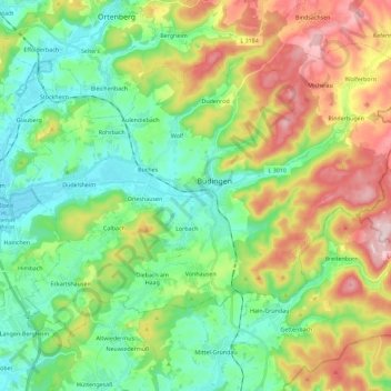
Name: Büdingen topographic map, elevation, terrain.
Location: Büdingen, Wetteraukreis, Hesse, 63654, Germany (50.22992 8.99986 50.34381 9.22762)
Average elevation: 712 ft
Minimum elevation: 394 ft
Maximum elevation: 1,316 ft
Make a donation
Gear up for your next adventure:
As an Amazon Associate, this site earns from qualifying purchases at no extra cost to you.