Geolocate

Argo topographic map

Click on the map to display elevation.

About this map

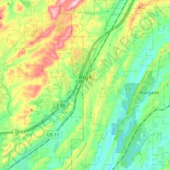
Name: Argo topographic map, elevation, terrain.

Location: Argo, St. Clair County, Alabama, United States (33.63726 -86.53736 33.74408 -86.47234)

Average elevation: 889 ft

Minimum elevation: 610 ft

Maximum elevation: 1,450 ft

St. Clair County trails, hiking, mountain biking, running and outdoor activities

Other topographic maps

Click on a map to view its topography, its elevation and its terrain.

Cook Springs

United States > Alabama > St. Clair County

Average elevation: 728 ft

Ragland

United States > Alabama > St. Clair County

Average elevation: 607 ft

Parsons

United States > Alabama > St. Clair County > Moody > Parsons

Average elevation: 702 ft

Cropwell

United States > Alabama > St. Clair County > Pell City

Average elevation: 509 ft

Gear up for your next adventure:

🗺️Topographic Maps - Detailed topo maps for hiking, exploring and outdoor navigation
🥘Titanium Cookware - Durable, featherlight pots and pans for backpacking
📌Outdoor GPS Map App - Apps and devices for digital topographic navigation
🥩Freeze-Dried Meals - Nutritious and lightweight food for remote expeditions
🪶Paracord Bracelet - Survival bracelet with built‑in tools

As an Amazon Associate, this site earns from qualifying purchases at no extra cost to you.