Geolocate

Lindos topographic map

Click on the map to display elevation.

About this map

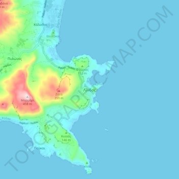
Name: Lindos topographic map, elevation, terrain.

Location: Lindos, Municipality of Rhodes, Rhodes Regional Unit, South Aegean, Aegean, 851 07, Greece (36.05156 28.04548 36.13156 28.12548)

Average elevation: 154 ft

Minimum elevation: 0 ft

Maximum elevation: 1,476 ft

Other topographic maps

Click on a map to view its topography, its elevation and its terrain.

Koskinou

Greece > Aegean > Rhodes Regional Unit

Average elevation: 236 ft

Tilos

Greece > Aegean > Rhodes Regional Unit > Agios Antonios

Average elevation: 141 ft

Ixia Beach

Greece > Aegean > Rhodes Regional Unit > Rhodes

Average elevation: 138 ft

Symi

Greece > Aegean > Rhodes Regional Unit > Emporios

Average elevation: 266 ft

Pedi Beach

Greece > Aegean > Rhodes Regional Unit > Pedi

Average elevation: 443 ft

Faliraki

Greece > Aegean > Rhodes Regional Unit

Average elevation: 85 ft

Megisti

Greece > Aegean > Rhodes Regional Unit > Municipality of Meyisti

West of the town, beyond the summit of the island known as Vigla (270 m), stands Palaiokastro (old castle), the island's ancient acropolis. This fortified elevation has classical origins (see below, history section): its plan is rectangular and measures 60 by 80 metres (200 ft × 260 ft). In its interior stand…

Average elevation: 131 ft

Gear up for your next adventure:

🪶Camping Sleeping Pad - Comfortable sleeping pad for backpacking
🗻Climbing Gear Basics - Essential gear for beginner climbers
🥘Titanium Cookware - Durable, featherlight pots and pans for backpacking
🧭GPS Watch Accessories - Bands and chargers for GPS watches
👟Men's Trail Runners - Lightweight footwear for fast-paced exploration and light hiking

As an Amazon Associate, this site earns from qualifying purchases at no extra cost to you.