
Make a donation
Gear up for your next adventure:
As an Amazon Associate, this site earns from qualifying purchases at no extra cost to you.
Mabalacat topographic map
Click on the map to display elevation.
Make a donation
Gear up for your next adventure:
As an Amazon Associate, this site earns from qualifying purchases at no extra cost to you.
About this map
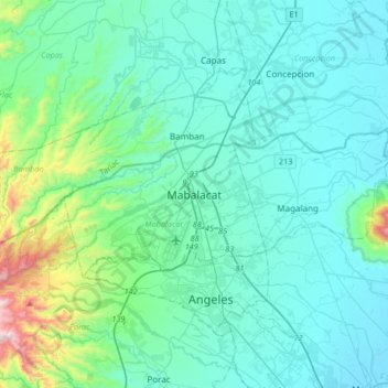
Name: Mabalacat topographic map, elevation, terrain.
Location: Mabalacat, Pampanga, Central Luzon, 2010, Philippines (15.06508 120.41338 15.38508 120.73338)
Average elevation: 489 ft
Minimum elevation: 13 ft
Maximum elevation: 3,524 ft
Make a donation
Gear up for your next adventure:
As an Amazon Associate, this site earns from qualifying purchases at no extra cost to you.
Other topographic maps
Click on a map to view its topography, its elevation and its terrain.
Guagua
The climate and topographical features of the vast land of Guagua make it ideal for the growing of fruit trees and vegetables. Among the fruit trees most fitting to be planted are mangoes, guavas, santol, star apples, and bananas. For vegetables, sitao, upo, ampalaya, gabi and cucumber are the most commonly…
Average elevation: 30 ft
Make a donation
Gear up for your next adventure:
As an Amazon Associate, this site earns from qualifying purchases at no extra cost to you.