
Make a donation
Gear up for your next adventure:
As an Amazon Associate, this site earns from qualifying purchases at no extra cost to you.
Adjuntas topographic map
Click on the map to display elevation.
Make a donation
Gear up for your next adventure:
As an Amazon Associate, this site earns from qualifying purchases at no extra cost to you.
Adjuntas
Adjuntas features a tropical rainforest climate that borders on a subtropical highland climate. While the town technically features a tropical rainforest climate, due to its high elevation, the climate is noticeably cooler than the norm for this climate category. Summers are warm (83°-85 °F) in the daytime and mild at nighttime (60°-63 °F). Meanwhile, winters are moderately warm with cool temperatures at night. During daytime, high temperatures are around 79 °F (26 °C) in the town and 68 °F (20 °C) in the nearby mountains. Winter night temperatures are between in the 55 °F (13 °C) and 60 °F (16 °C) range, but after cold fronts temperatures can drop down to 45 °F (7 °C).
Make a donation
Gear up for your next adventure:
As an Amazon Associate, this site earns from qualifying purchases at no extra cost to you.
About this map
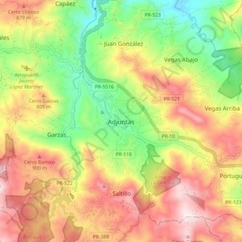
Name: Adjuntas topographic map, elevation, terrain.
Location: Adjuntas, Puerto Rico, 00601, United States (18.12256 -66.76314 18.20256 -66.68314)
Average elevation: 2,257 ft
Minimum elevation: 1,148 ft
Maximum elevation: 3,406 ft
Adjuntas trails, hiking, mountain biking, running and outdoor activities
Make a donation
Gear up for your next adventure:
As an Amazon Associate, this site earns from qualifying purchases at no extra cost to you.