
Make a donation
Gear up for your next adventure:
As an Amazon Associate, this site earns from qualifying purchases at no extra cost to you.
Glatt topographic map
Click on the map to display elevation.
Make a donation
Gear up for your next adventure:
As an Amazon Associate, this site earns from qualifying purchases at no extra cost to you.
Glatt
Der rechte Oberlauf Stockerbach der Glatt entspringt dagegen höher auf etwa 753 m ü. NHN dem Kratzenhartbrunnen, der etwa 2 km westlich des Glattbrunnens im Reichenbacher Wald auf Freudenstadter Gebiet liegt. Ihm fließen von rechts einige Bäche zu, die damit sein Teileinzugsgebiets etwa anderthalb mal so groß machen wie das seines linken Partners.
Make a donation
Gear up for your next adventure:
As an Amazon Associate, this site earns from qualifying purchases at no extra cost to you.
About this map
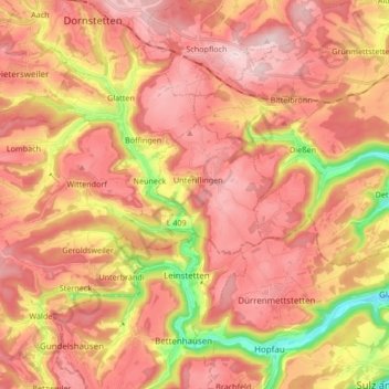
Name: Glatt topographic map, elevation, terrain.
Average elevation: 1,991 ft
Minimum elevation: 1,355 ft
Maximum elevation: 2,365 ft
Make a donation
Gear up for your next adventure:
As an Amazon Associate, this site earns from qualifying purchases at no extra cost to you.
Other topographic maps
Click on a map to view its topography, its elevation and its terrain.
Marschalkenzimmern
Deutschland > Baden-Württemberg > Landkreis Rottweil > Dornhan > Marschalkenzimmern
Average elevation: 2,119 ft