
Make a donation
Gear up for your next adventure:
As an Amazon Associate, this site earns from qualifying purchases at no extra cost to you.
Trnava topographic map
Click on the map to display elevation.
Make a donation
Gear up for your next adventure:
As an Amazon Associate, this site earns from qualifying purchases at no extra cost to you.
Trnava
Trnava lies at an altitude of 146 metres (479 ft) above sea level and covers an area of 71.535 square kilometres (27.6 sq mi). It is located in the Danubian Lowland on the Trnávka river, around 45 kilometres (28 mi) north-east of Bratislava, 50 kilometres (31 mi) west of Nitra and around 70 kilometres (43 mi) from the Czech border. The closest mountain ranges are the Little Carpathians to the west and the Považský Inovec to the north-east of the city.
Make a donation
Gear up for your next adventure:
As an Amazon Associate, this site earns from qualifying purchases at no extra cost to you.
About this map
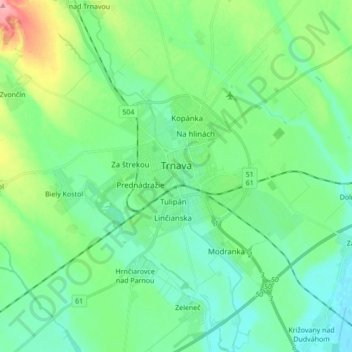
Name: Trnava topographic map, elevation, terrain.
Average elevation: 505 ft
Minimum elevation: 423 ft
Maximum elevation: 748 ft
Make a donation
Gear up for your next adventure:
As an Amazon Associate, this site earns from qualifying purchases at no extra cost to you.