Geolocate

Claygate topographic map

Click on the map to display elevation.

About this map

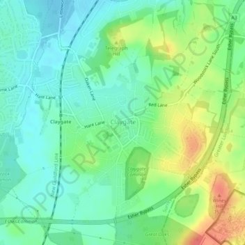
Name: Claygate topographic map, elevation, terrain.

Location: Claygate, Elmbridge, Surrey, England, United Kingdom (51.34922 -0.35681 51.37127 -0.31792)

Average elevation: 118 ft

Minimum elevation: 52 ft

Maximum elevation: 243 ft

Gear up for your next adventure:

🪶Camping Sleeping Pad - Comfortable sleeping pad for backpacking
📱Heavy-Duty Phone Cases - Drop-proof and waterproof protection for outdoor navigation
🥩Freeze-Dried Meals - Nutritious and lightweight food for remote expeditions
🧯Portable Fire Pit - Compact fire pit for camping spots
📶Satellite Messenger - Communication device off‑grid

As an Amazon Associate, this site earns from qualifying purchases at no extra cost to you.