
Make a donation
Gear up for your next adventure:
As an Amazon Associate, this site earns from qualifying purchases at no extra cost to you.
Rangpur topographic map
Click on the map to display elevation.
Make a donation
Gear up for your next adventure:
As an Amazon Associate, this site earns from qualifying purchases at no extra cost to you.
Rangpur
Rangpur City is the divisional headquarters of Rangpur Division. The soil composition is mainly alluvial soil (80 percent) of the Teesta River basin, and the remaining is barind soil. The elevation of Rangpur is 34 meters. The temperature ranges from 32 degrees Celsius to 11 degrees Celsius, and the annual rainfall averages 2931 mm. Rangpur town, covering an area of around 42 square kilometers, lies on the bank of the Ghaghat river and was turned into a municipality back in 1869.
Make a donation
Gear up for your next adventure:
As an Amazon Associate, this site earns from qualifying purchases at no extra cost to you.
About this map
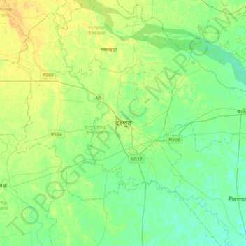
Name: Rangpur topographic map, elevation, terrain.
Average elevation: 108 ft
Minimum elevation: 82 ft
Maximum elevation: 144 ft
Make a donation
Gear up for your next adventure:
As an Amazon Associate, this site earns from qualifying purchases at no extra cost to you.