
Make a donation
Gear up for your next adventure:
As an Amazon Associate, this site earns from qualifying purchases at no extra cost to you.
Faveraye-Mâchelles topographic map
Click on the map to display elevation.
Make a donation
Gear up for your next adventure:
As an Amazon Associate, this site earns from qualifying purchases at no extra cost to you.
About this map
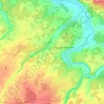
Name: Faveraye-Mâchelles topographic map, elevation, terrain.
Average elevation: 194 ft
Minimum elevation: 85 ft
Maximum elevation: 312 ft
Make a donation
Gear up for your next adventure:
As an Amazon Associate, this site earns from qualifying purchases at no extra cost to you.
Other topographic maps
Click on a map to view its topography, its elevation and its terrain.
La Ribellerie
France > Pays de la Loire > Maine-et-Loire > Bellevigne-en-Layon
Average elevation: 276 ft
Château De Fesles
France > Pays de la Loire > Maine-et-Loire > Bellevigne-en-Layon
Average elevation: 226 ft
Les Charlottes
France > Pays de la Loire > Maine-et-Loire > Bellevigne-en-Layon
Average elevation: 190 ft
Layon (bras)
France > Pays de la Loire > Maine-et-Loire > Bellevigne-en-Layon
Average elevation: 187 ft
Make a donation
Gear up for your next adventure:
As an Amazon Associate, this site earns from qualifying purchases at no extra cost to you.
Montbenault
France > Pays de la Loire > Maine-et-Loire > Bellevigne-en-Layon
Average elevation: 253 ft
Chasles
France > Pays de la Loire > Maine-et-Loire > Bellevigne-en-Layon > Chasles
Average elevation: 180 ft