Geolocate

Onano topographic map

Click on the map to display elevation.

About this map

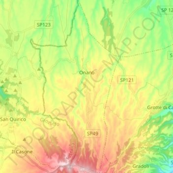
Name: Onano topographic map, elevation, terrain.

Location: Onano, Viterbo, Lazio, Italy (42.63999 11.77614 42.73082 11.84059)

Average elevation: 1,598 ft

Minimum elevation: 1,145 ft

Maximum elevation: 2,152 ft

Other topographic maps

Click on a map to view its topography, its elevation and its terrain.

Bagnaia

Italy > Lazio > Viterbo > Viterbo

Average elevation: 1,522 ft

Isola Bisentina

Italy > Lazio > Viterbo > Capodimonte

Average elevation: 997 ft

Cura

Italy > Lazio > Viterbo > Vetralla

Average elevation: 1,289 ft

Gear up for your next adventure:

📶Vehicle Signal Boosters - Improve reception in rural areas while driving to trailheads
📦Gear Storage Bags - Organize and protect outdoor equipment
🎒Trail Energy Bars - High‑calorie bars for hiking energy
⛑️Personal Locator Beacon - Safety beacon for emergencies
🧭Map Reading Tools - Tools and kits for map navigation

As an Amazon Associate, this site earns from qualifying purchases at no extra cost to you.