
Thank you for supporting this site ❤️
Make a donation
Make a donation
Gear up for your next adventure:
As an Amazon Associate, this site earns from qualifying purchases at no extra cost to you.
Mohammadia topographic map
Click on the map to display elevation.
Thank you for supporting this site ❤️
Make a donation
Make a donation
Gear up for your next adventure:
As an Amazon Associate, this site earns from qualifying purchases at no extra cost to you.
About this map
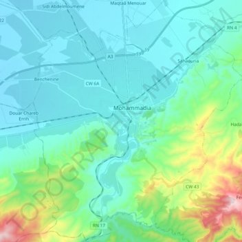
Name: Mohammadia topographic map, elevation, terrain.
Location: Mohammadia, Mohammadia District, Mascara, 29002, Algeria (35.50470 -0.00955 35.65658 0.15268)
Average elevation: 479 ft
Minimum elevation: 46 ft
Maximum elevation: 2,320 ft
Thank you for supporting this site ❤️
Make a donation
Make a donation
Gear up for your next adventure:
As an Amazon Associate, this site earns from qualifying purchases at no extra cost to you.