
Make a donation
Gear up for your next adventure:
As an Amazon Associate, this site earns from qualifying purchases at no extra cost to you.
Southern Red Sea Region topographic map
Click on the map to display elevation.
Make a donation
Gear up for your next adventure:
As an Amazon Associate, this site earns from qualifying purchases at no extra cost to you.
Southern Red Sea Region
The Southern Red Sea Region extends over 500 km (310 mi) along Red Sea coast but is only around 50 km (31 mi) wide. Forming the major part of the Danakil Desert, its major towns include Asseb, Beilul, Rahaita and T'i'o. The highest point in this region is Mount Ramlu (2,248 metres (7,375 ft)). It is generally considered one of the hottest, driest and most inhospitable regions in the country. The topography of the region has coastal plains, which are hotter than the regions around the highland plateau. There are two rainy seasons, the heavier one during summer and the lighter one during spring. The climate and geography of the region along with other regions of Eritrea is similar to the one of Ethiopia. The hottest month is May recording temperatures up to 30 °C (86 °F), while the coldest month is December to February when it reaches freezing temperature. The region received around 200 mm (7.9 in) of rainfall and the soil is salty and not conducive for agriculture.
Make a donation
Gear up for your next adventure:
As an Amazon Associate, this site earns from qualifying purchases at no extra cost to you.
About this map
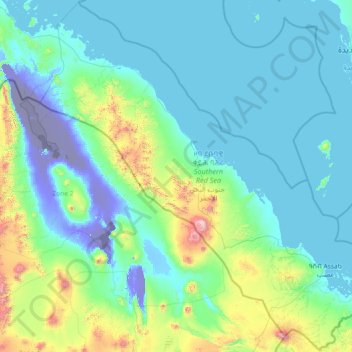
Name: Southern Red Sea Region topographic map, elevation, terrain.
Location: Southern Red Sea Region, Eritrea (12.35482 40.36499 15.18047 43.30017)
Average elevation: 594 ft
Minimum elevation: -413 ft
Maximum elevation: 6,985 ft
Make a donation
Gear up for your next adventure:
As an Amazon Associate, this site earns from qualifying purchases at no extra cost to you.
Other topographic maps
Click on a map to view its topography, its elevation and its terrain.
Make a donation
Gear up for your next adventure:
As an Amazon Associate, this site earns from qualifying purchases at no extra cost to you.
Make a donation
Gear up for your next adventure:
As an Amazon Associate, this site earns from qualifying purchases at no extra cost to you.
Make a donation
Gear up for your next adventure:
As an Amazon Associate, this site earns from qualifying purchases at no extra cost to you.