
Myakka City topographic map
Interactive map
Click on the map to display elevation.
Myakka City
Myakka City (also Myakka) is an unincorporated community in southeastern Manatee County, Florida, United States. It lies along State Road 70 near the city of Bradenton, the county seat of Manatee County. Its elevation is 43 feet (13 m), and it is located at 27°20′59″N 82°9′41″W / 27.34972°N 82.16139°W / 27.34972; -82.16139 (27.3497671, -82.1614780). Although Myakka is unincorporated, it has a post office, with the ZIP code of 34251; the ZCTA for ZIP code 34251 had a population of 6,351 at the 2010 census. up from 4,239 in 2000.
About this map
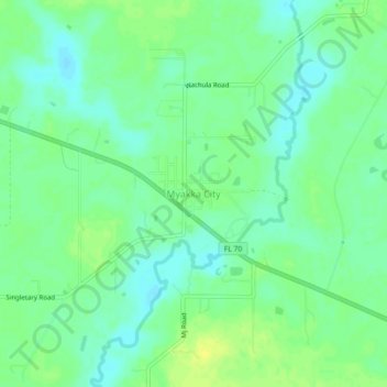
Name: Myakka City topographic map, elevation, terrain.
Location: Myakka City, Manatee County, Florida, United States (27.32977 -82.18148 27.36977 -82.14148)
Average elevation: 46 ft
Minimum elevation: 16 ft
Maximum elevation: 82 ft
Manatee County trails, hiking, mountain biking, running and outdoor activities
Other topographic maps
Click on a map to view its topography, its elevation and its terrain.
Summerfield Community Park
United States > Florida > Manatee County > Bradenton
Average elevation: 33 ft
Anna Maria Bayfront Park
United States > Florida > Manatee County > Anna Maria island
Average elevation: 3 ft