
Srinagar topographic map
Click on the map to display elevation.
Srinagar
Srinagar is located at 30°13′N 78°47′E / 30.22°N 78.78°E / 30.22; 78.78. at the left bank of Alaknanda river. It has an average elevation of 560 metres (1,837 feet). It is the largest town in the Garhwal Hills. It is reached by national highway NH58 from Rishikesh, Srinagar is about 104 km from Rishikesh which is the last city on the plains of Uttarakhand and from where the mountains start. Srinagar can also be reached via Kotdwara, from Kotdwara it takes maximum 5 hours to reach there.It is a municipal board in the Pauri district of uttarakhand which is now upgraded to Municipal Corporation recently.
About this map
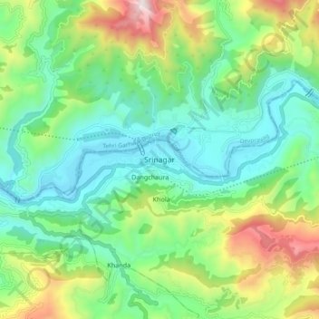
Name: Srinagar topographic map, elevation, terrain.
Location: Srinagar, Pauri Garhwal, Uttarakhand, 249127, India (30.18381 78.74790 30.26381 78.82790)
Average elevation: 2,818 ft
Minimum elevation: 1,680 ft
Maximum elevation: 5,472 ft
Other topographic maps
Click on a map to view its topography, its elevation and its terrain.