
Make a donation
Gear up for your next adventure:
As an Amazon Associate, this site earns from qualifying purchases at no extra cost to you.
Sawantwadi topographic map
Click on the map to display elevation.
Make a donation
Gear up for your next adventure:
As an Amazon Associate, this site earns from qualifying purchases at no extra cost to you.
Sawantwadi
Sawantwadi is located at 16°00′N 73°45′E / 16°N 73.75°E / 16; 73.75 in the Sindhudurg district of Maharashtra. It has an average elevation of 22 metres (72 ft) above mean sea level. It is the administrative headquarters of the Sindhudurg district. Sawantwadi is situated on the west coast of Maharashtra, India, and is bounded by the Arabian Sea to its west and the Western Ghats to its east. As a municipal entity, it spans an area of 132.45 km2 (51.14 sq mi), and experiences moderate to gusty winds during the day and gentle winds at night. The topography of the city ranges from plain to undulating, with several hills, valleys and flat areas within the city. The geology of the city is characterised by hard laterite in hilly tracts and sandy soil along the seashore.
Make a donation
Gear up for your next adventure:
As an Amazon Associate, this site earns from qualifying purchases at no extra cost to you.
About this map
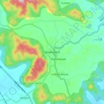
Name: Sawantwadi topographic map, elevation, terrain.
Average elevation: 381 ft
Minimum elevation: 62 ft
Maximum elevation: 1,247 ft
Make a donation
Gear up for your next adventure:
As an Amazon Associate, this site earns from qualifying purchases at no extra cost to you.