
Grand-Halleux topographic map
Interactive map
Click on the map to display elevation.
About this map
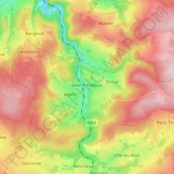
Name: Grand-Halleux topographic map, elevation, terrain.
Average elevation: 1,437 ft
Minimum elevation: 846 ft
Maximum elevation: 1,962 ft
Other topographic maps
Click on a map to view its topography, its elevation and its terrain.
Baraque de Fraiture
België > Luxemburg > Bastenaken > Vielsalm
Baraque de Fraiture (ook wel Baraque Fraiture) is het hoogste punt van het Plateau des Tailles in de Belgische Ardennen. Het is 651 meter (boven TAW) hoog en ontleent zijn naam aan het nabijgelegen dorpje Fraiture en een tijdelijke herberg ('baraque') op dit punt (zie ook Baraque Michel). De topografische…
Average elevation: 2,001 ft