
Make a donation
Gear up for your next adventure:
As an Amazon Associate, this site earns from qualifying purchases at no extra cost to you.
Mauston topographic map
Click on the map to display elevation.
Make a donation
Gear up for your next adventure:
As an Amazon Associate, this site earns from qualifying purchases at no extra cost to you.
Mauston
Mauston is located at 43°48′N 90°5′W / 43.800°N 90.083°W / 43.800; -90.083 (43.798, -90.077). It is in the Central Standard time zone. Elevation is 883 feet.
Make a donation
Gear up for your next adventure:
As an Amazon Associate, this site earns from qualifying purchases at no extra cost to you.
About this map
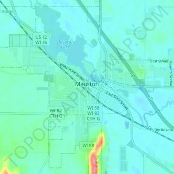
Name: Mauston topographic map, elevation, terrain.
Location: Mauston, Juneau County, Wisconsin, 53948, United States (43.77398 -90.11176 43.81855 -90.04509)
Average elevation: 889 ft
Minimum elevation: 853 ft
Maximum elevation: 1,129 ft
Juneau County trails, hiking, mountain biking, running and outdoor activities
Make a donation
Gear up for your next adventure:
As an Amazon Associate, this site earns from qualifying purchases at no extra cost to you.
Other topographic maps
Click on a map to view its topography, its elevation and its terrain.