Geolocate

Copperhill topographic map

Click on the map to display elevation.

About this map

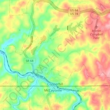
Name: Copperhill topographic map, elevation, terrain.

Location: Copperhill, Polk County, East Tennessee, Tennessee, United States (34.98809 -84.40195 35.01758 -84.33852)

Average elevation: 1,617 ft

Minimum elevation: 1,427 ft

Maximum elevation: 1,824 ft

Polk County trails, hiking, mountain biking, running and outdoor activities

Other topographic maps

Click on a map to view its topography, its elevation and its terrain.

Delano

United States > Tennessee > Polk County

Average elevation: 846 ft

Turtletown

United States > Tennessee > Polk County

Average elevation: 1,696 ft

Reliance

United States > Tennessee > Polk County

Average elevation: 1,007 ft

Hambright

United States > Tennessee > Polk County

Average elevation: 1,152 ft

Farner

United States > Tennessee > Polk County

Average elevation: 1,535 ft

Patty

United States > Tennessee > Polk County

Average elevation: 764 ft

Ocoee

United States > Tennessee > Polk County

Average elevation: 804 ft

Turtletown

United States > Tennessee > Polk County

Average elevation: 1,696 ft

Gear up for your next adventure:

🪶LED Camping Lantern - Bright lantern for camp lighting
🪶Camping Sleeping Pad - Comfortable sleeping pad for backpacking
🎒Waterproof Dry Bags - Keep your electronics and maps dry inside your pack
🎒Trekking Poles - Sturdy poles for balance and stability on rough terrain
🖼️Topo Map Wall Art - Decorative topographic prints of famous peaks and regions

As an Amazon Associate, this site earns from qualifying purchases at no extra cost to you.