Geolocate

Patty topographic map

Click on the map to display elevation.

About this map

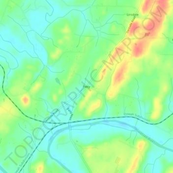
Name: Patty topographic map, elevation, terrain.

Location: Patty, Polk County, Tennessee, United States (35.21480 -84.66105 35.25480 -84.62105)

Average elevation: 764 ft

Minimum elevation: 689 ft

Maximum elevation: 896 ft

Other topographic maps

Click on a map to view its topography, its elevation and its terrain.

Copperhill

United States > Tennessee > Polk County

Average elevation: 1,617 ft

Ducktown

United States > Tennessee > Polk County

Average elevation: 1,686 ft

Copperhill

United States > Tennessee > Polk County

Average elevation: 1,617 ft

Ducktown

United States > Tennessee > Polk County

Average elevation: 1,686 ft

Copperhill

United States > Tennessee > Polk County

Average elevation: 1,617 ft

Gear up for your next adventure:

🧣Hiking Neck Gaiter - Multi‑use neck protection for outdoor weather
🥘Titanium Cookware - Durable, featherlight pots and pans for backpacking
📷Action Camera - Capture your outdoor adventures in HD
🧤Tactile Hiking Gloves - Keep hands warm while operating GPS and smartphone screens
📦Gear Storage Bags - Organize and protect outdoor equipment

As an Amazon Associate, this site earns from qualifying purchases at no extra cost to you.