
Make a donation
Gear up for your next adventure:
As an Amazon Associate, this site earns from qualifying purchases at no extra cost to you.
High Hill topographic map
Click on the map to display elevation.
Make a donation
Gear up for your next adventure:
As an Amazon Associate, this site earns from qualifying purchases at no extra cost to you.
High Hill
A post office called High Hill has been in operation since 1837. The community was so named on account of its lofty elevation.
Make a donation
Gear up for your next adventure:
As an Amazon Associate, this site earns from qualifying purchases at no extra cost to you.
About this map
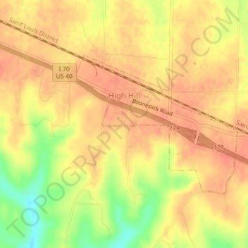
Name: High Hill topographic map, elevation, terrain.
Location: High Hill, Montgomery County, Missouri, United States (38.86767 -91.39059 38.88279 -91.36760)
Average elevation: 866 ft
Minimum elevation: 755 ft
Maximum elevation: 909 ft
Montgomery County trails, hiking, mountain biking, running and outdoor activities
Make a donation
Gear up for your next adventure:
As an Amazon Associate, this site earns from qualifying purchases at no extra cost to you.
Other topographic maps
Click on a map to view its topography, its elevation and its terrain.