
Make a donation
Gear up for your next adventure:
As an Amazon Associate, this site earns from qualifying purchases at no extra cost to you.
Altavista topographic map
Click on the map to display elevation.
Make a donation
Gear up for your next adventure:
As an Amazon Associate, this site earns from qualifying purchases at no extra cost to you.
About this map
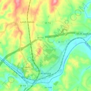
Name: Altavista topographic map, elevation, terrain.
Location: Altavista, Campbell County, Virginia, 24517, United States (37.10484 -79.32101 37.15653 -79.24364)
Average elevation: 656 ft
Minimum elevation: 492 ft
Maximum elevation: 938 ft
Campbell County trails, hiking, mountain biking, running and outdoor activities
Make a donation
Gear up for your next adventure:
As an Amazon Associate, this site earns from qualifying purchases at no extra cost to you.
Other topographic maps
Click on a map to view its topography, its elevation and its terrain.
Rustburg
United States > Virginia > Campbell County
Rustburg is located in north-central Campbell County at 37°16′25″N 79°05′56″W / 37.273731°N 79.098914°W / 37.273731; -79.098914 (37.273731, −79.098914). U.S. Route 501 passes through the center of town, leading north 11 miles (18 km) to Lynchburg and south 20 miles (32 km) to Brookneal.…
Average elevation: 892 ft