Geolocate

Askim topographic map

Click on the map to display elevation.

About this map

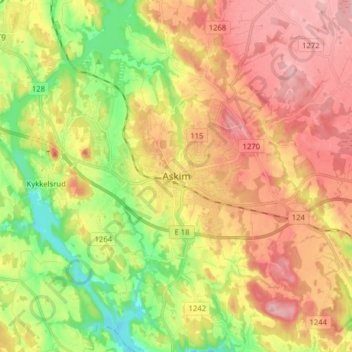
Name: Askim topographic map, elevation, terrain.

Location: Askim, Indre Østfold, Østfold, 1830, Norway (59.54322 11.12419 59.62322 11.20419)

Average elevation: 427 ft

Minimum elevation: 180 ft

Maximum elevation: 650 ft

Other topographic maps

Click on a map to view its topography, its elevation and its terrain.

Ullerøy leirskole

Norway > Østfold > Ullerøy

Average elevation: 46 ft

Kinnekulle

Norway > Østfold

Average elevation: 486 ft

Skiptvet

Norway > Østfold

Average elevation: 381 ft

Moss

Norway > Østfold

Average elevation: 75 ft

Ertevannet

Norway > Østfold

Average elevation: 404 ft

Knivsøya

Norway > Østfold > Isebakke

Average elevation: 112 ft

Halden

Norway > Østfold

Average elevation: 410 ft

Moss

Norway > Østfold

Average elevation: 75 ft

Fredrikstad

Norway > Østfold

Average elevation: 49 ft

Gear up for your next adventure:

😴Insulated Sleeping Pads - Compact and warm pads for high-elevation camping
🥘Titanium Cookware - Durable, featherlight pots and pans for backpacking
🚗GPS Dash Cams - Record your scenic drives through mountain passes and canyons
🦟Ultrasonic Repellers - Create a bug-free zone at your camp or rest stop
🧴Hand Sanitizer - Keep hands clean while hiking

As an Amazon Associate, this site earns from qualifying purchases at no extra cost to you.