
Make a donation
Gear up for your next adventure:
As an Amazon Associate, this site earns from qualifying purchases at no extra cost to you.
Vilkerath topographic map
Click on the map to display elevation.
Make a donation
Gear up for your next adventure:
As an Amazon Associate, this site earns from qualifying purchases at no extra cost to you.
Vilkerath
Am 23. Januar 1961 stürzte zwischen Vilkerath und Bengelshöhe eine Transportmaschine vom Typ Noratlas der Bundeswehr ab. Alle vier Besatzungsmitglieder kamen beim Absturz ums Leben.
Make a donation
Gear up for your next adventure:
As an Amazon Associate, this site earns from qualifying purchases at no extra cost to you.
About this map
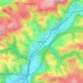
Name: Vilkerath topographic map, elevation, terrain.
Average elevation: 551 ft
Minimum elevation: 308 ft
Maximum elevation: 866 ft
Make a donation
Gear up for your next adventure:
As an Amazon Associate, this site earns from qualifying purchases at no extra cost to you.
Other topographic maps
Click on a map to view its topography, its elevation and its terrain.
Breidenassel
Deutschland > Nordrhein-Westfalen > Rheinisch-Bergischer Kreis > Overath
Average elevation: 597 ft