
Thank you for supporting this site ❤️
Make a donation
Make a donation
Gear up for your next adventure:
As an Amazon Associate, this site earns from qualifying purchases at no extra cost to you.
Sechshelden topographic map
Click on the map to display elevation.
Thank you for supporting this site ❤️
Make a donation
Make a donation
Gear up for your next adventure:
As an Amazon Associate, this site earns from qualifying purchases at no extra cost to you.
About this map
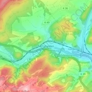
Name: Sechshelden topographic map, elevation, terrain.
Location: Sechshelden, Haiger, Lahn-Dill-Kreis, Hessen, 35685, Deutschland (50.72677 8.23085 50.76677 8.27085)
Average elevation: 1,024 ft
Minimum elevation: 751 ft
Maximum elevation: 1,463 ft
Thank you for supporting this site ❤️
Make a donation
Make a donation
Gear up for your next adventure:
As an Amazon Associate, this site earns from qualifying purchases at no extra cost to you.