
Darien topographic map
Click on the map to display elevation.
Darien
On its east side, Long Neck Point Road stretches south beginning near the Ring's End Landing bridge and terminating at the southerly most tip of land. This area is somewhat inland and away from the eastern shoreline and at a relatively high elevation above the water. The west coast of Long Neck runs along Goodwives River and includes Pear Tree Point. Situated on Noroton Harbor, Pear Tree Point includes a public beach (Pear Tree Point Beach Park) and a private club (Darien Boat Club). Pear Tree Point Road, begins at the Ring's End Landing bridge, runs south along the western side of Long Neck adjacent to "The Gut" and to outer Noroton Harbor. This charming route hugs the shoreline at an elevation close enough to the tides such that storm conditions can bring the water level over the road. Approximately half-way south along the peninsula, Pear Tree Point Road turns abruptly to the east, ninety degrees, heading uphill and connecting to Long Neck Point Road, distinguishing Long Neck from Long Neck Point.
About this map
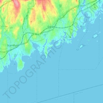
Name: Darien topographic map, elevation, terrain.
Average elevation: 39 ft
Minimum elevation: -7 ft
Maximum elevation: 322 ft
Western Connecticut Planning Region trails, hiking, mountain biking, running and outdoor activities
Other topographic maps
Click on a map to view its topography, its elevation and its terrain.
Old Greenwich
United States > Connecticut > Western Connecticut Planning Region > Greenwich
Average elevation: 39 ft
Riverside
United States > Connecticut > Western Connecticut Planning Region > Greenwich > Old Greenwich
Average elevation: 43 ft
Pinneys Corners
United States > Connecticut > Western Connecticut Planning Region > New Canaan
Average elevation: 469 ft
Sandy Hook
United States > Connecticut > Western Connecticut Planning Region > Newtown
Average elevation: 371 ft
Northfield
United States > Connecticut > Western Connecticut Planning Region > Stamford
Average elevation: 82 ft
Candlewood Lake Club
United States > Connecticut > Western Connecticut Planning Region > New Milford
Average elevation: 469 ft
Cannondale
United States > Connecticut > Western Connecticut Planning Region > Wilton
Average elevation: 361 ft
Taylor Corners
United States > Connecticut > Western Connecticut Planning Region > New Fairfield
Average elevation: 741 ft
Mianus
United States > Connecticut > Western Connecticut Planning Region > Greenwich
Average elevation: 75 ft
Winnipauk
United States > Connecticut > Western Connecticut Planning Region > Norwalk
Average elevation: 167 ft
West Norwalk
United States > Connecticut > Western Connecticut Planning Region > Norwalk
Average elevation: 164 ft
Godfrey Corner
United States > Connecticut > Western Connecticut Planning Region > Weston
Average elevation: 361 ft
North Mianus
United States > Connecticut > Western Connecticut Planning Region > Greenwich
Average elevation: 105 ft
Saugatuck
United States > Connecticut > Western Connecticut Planning Region > Westport
Average elevation: 49 ft
Five Points
United States > Connecticut > Western Connecticut Planning Region > Redding Ridge
Average elevation: 607 ft
Daniels Mill
United States > Connecticut > Western Connecticut Planning Region > New Canaan
Average elevation: 328 ft
Thomas Mountain
United States > Connecticut > Western Connecticut Planning Region > Danbury
Average elevation: 646 ft
Germantown
United States > Connecticut > Western Connecticut Planning Region > Danbury
Average elevation: 397 ft
King Street
United States > Connecticut > Western Connecticut Planning Region > Danbury
Average elevation: 778 ft
Hurds Corner
United States > Connecticut > Western Connecticut Planning Region > New Milford
Average elevation: 486 ft
Lanesville
United States > Connecticut > Western Connecticut Planning Region > New Milford
Average elevation: 348 ft
Beaver Brook
United States > Connecticut > Western Connecticut Planning Region > Danbury
Average elevation: 390 ft
Miry Brook
United States > Connecticut > Western Connecticut Planning Region > Danbury
Average elevation: 610 ft
King Street
United States > Connecticut > Western Connecticut Planning Region > Danbury
Average elevation: 778 ft
North Stamford
United States > Connecticut > Western Connecticut Planning Region > Stamford
Average elevation: 292 ft
Ponus
United States > Connecticut > Western Connecticut Planning Region > New Canaan
Average elevation: 253 ft
Great Plain
United States > Connecticut > Western Connecticut Planning Region > Danbury
Average elevation: 433 ft
Mianus
United States > Connecticut > Western Connecticut Planning Region > Greenwich
Average elevation: 75 ft
Five Points
United States > Connecticut > Western Connecticut Planning Region > Redding Ridge
Average elevation: 607 ft
Northfield
United States > Connecticut > Western Connecticut Planning Region > Stamford
Average elevation: 82 ft
Wataba Lake
United States > Connecticut > Western Connecticut Planning Region > Ridgefield
Average elevation: 673 ft
Beckettville
United States > Connecticut > Western Connecticut Planning Region > Danbury
Average elevation: 509 ft
Roxbury
United States > Connecticut > Western Connecticut Planning Region > Stamford
Average elevation: 157 ft
Deer Hill
United States > Connecticut > Western Connecticut Planning Region > Danbury
Average elevation: 443 ft
Long Ridge
United States > Connecticut > Western Connecticut Planning Region > Stamford
Average elevation: 413 ft
Belltown
United States > Connecticut > Western Connecticut Planning Region > Stamford
Average elevation: 105 ft
Town Open Space (Ashford Lane)
United States > Connecticut > Western Connecticut Planning Region > Newtown
Average elevation: 656 ft
Byram
United States > Connecticut > Western Connecticut Planning Region > Greenwich
Average elevation: 62 ft
South End
United States > Connecticut > Western Connecticut Planning Region > Stamford
Average elevation: 36 ft
Tokeneke
United States > Connecticut > Western Connecticut Planning Region > Darien
Average elevation: 46 ft
King Street
United States > Connecticut > Western Connecticut Planning Region > Danbury
Average elevation: 778 ft
Contentment Island
United States > Connecticut > Western Connecticut Planning Region > Darien
Average elevation: 207 ft
Godfrey Corner
United States > Connecticut > Western Connecticut Planning Region > Weston
Average elevation: 361 ft
Bold Rock
United States > Connecticut > Western Connecticut Planning Region > Darien
Average elevation: 190 ft
Mill River Park
United States > Connecticut > Western Connecticut Planning Region > Stamford
Average elevation: 59 ft
Wildmans Landing
United States > Connecticut > Western Connecticut Planning Region > Danbury
Average elevation: 512 ft
Chimney Point
United States > Connecticut > Western Connecticut Planning Region > New Milford
Average elevation: 466 ft
Palestine
United States > Connecticut > Western Connecticut Planning Region > Newtown
Average elevation: 604 ft
Taylor Corners
United States > Connecticut > Western Connecticut Planning Region > New Fairfield
Average elevation: 741 ft
Palmers Hill
United States > Connecticut > Western Connecticut Planning Region > Stamford
Average elevation: 102 ft
Glenville
United States > Connecticut > Western Connecticut Planning Region > Greenwich
Average elevation: 177 ft
Turn of River
United States > Connecticut > Western Connecticut Planning Region > Stamford
Average elevation: 190 ft
Candlewood Orchards
United States > Connecticut > Western Connecticut Planning Region > Brookfield
Average elevation: 463 ft
Riverside
United States > Connecticut > Western Connecticut Planning Region > Greenwich > Old Greenwich
Average elevation: 43 ft
Candlewood Springs
United States > Connecticut > Western Connecticut Planning Region > New Milford
Average elevation: 479 ft