
Make a donation
Gear up for your next adventure:
As an Amazon Associate, this site earns from qualifying purchases at no extra cost to you.
Thessaloniki topographic map
Click on the map to display elevation.
Make a donation
Gear up for your next adventure:
As an Amazon Associate, this site earns from qualifying purchases at no extra cost to you.
About this map
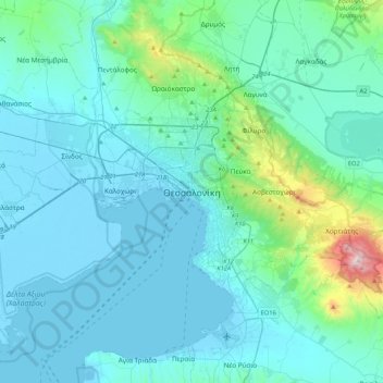
Name: Thessaloniki topographic map, elevation, terrain.
Average elevation: 413 ft
Minimum elevation: -13 ft
Maximum elevation: 3,875 ft
Make a donation
Gear up for your next adventure:
As an Amazon Associate, this site earns from qualifying purchases at no extra cost to you.
Other topographic maps
Click on a map to view its topography, its elevation and its terrain.
Municipal Unit of Assiros
Greece > Macedonia and Thrace > Thessaloniki Regional Unit
Average elevation: 886 ft
Pylaia Municipal Unit
Greece > Macedonia and Thrace > Thessaloniki Regional Unit
Average elevation: 390 ft
Pylaia Municipal Unit
Greece > Macedonia and Thrace > Thessaloniki Regional Unit
Average elevation: 390 ft
Make a donation
Gear up for your next adventure:
As an Amazon Associate, this site earns from qualifying purchases at no extra cost to you.
Thessaloniki Municipal Unit
Greece > Macedonia and Thrace > Thessaloniki Regional Unit
Average elevation: 279 ft