
Thank you for supporting this site ❤️
Make a donation
Make a donation
Gear up for your next adventure:
As an Amazon Associate, this site earns from qualifying purchases at no extra cost to you.
Les Plans de Comburce topographic map
Click on the map to display elevation.
Thank you for supporting this site ❤️
Make a donation
Make a donation
Gear up for your next adventure:
As an Amazon Associate, this site earns from qualifying purchases at no extra cost to you.
About this map
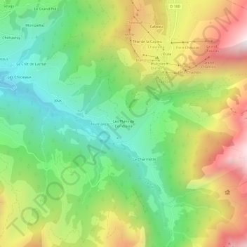
Name: Les Plans de Comburce topographic map, elevation, terrain.
Average elevation: 4,406 ft
Minimum elevation: 2,756 ft
Maximum elevation: 6,798 ft
Thank you for supporting this site ❤️
Make a donation
Make a donation
Gear up for your next adventure:
As an Amazon Associate, this site earns from qualifying purchases at no extra cost to you.
Other topographic maps
Click on a map to view its topography, its elevation and its terrain.
Lac du Champ Tardif
France > Auvergne-Rhône-Alpes > Haute-Savoie > Manigod
Average elevation: 5,568 ft
Lac du Mont Charvin
France > Auvergne-Rhône-Alpes > Haute-Savoie > Manigod
Average elevation: 5,892 ft