
Make a donation
Gear up for your next adventure:
As an Amazon Associate, this site earns from qualifying purchases at no extra cost to you.
Granges-Sainte-Marie topographic map
Click on the map to display elevation.
Make a donation
Gear up for your next adventure:
As an Amazon Associate, this site earns from qualifying purchases at no extra cost to you.
About this map
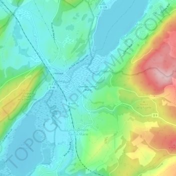
Name: Granges-Sainte-Marie topographic map, elevation, terrain.
Average elevation: 2,979 ft
Minimum elevation: 2,779 ft
Maximum elevation: 3,488 ft
Make a donation
Gear up for your next adventure:
As an Amazon Associate, this site earns from qualifying purchases at no extra cost to you.
Other topographic maps
Click on a map to view its topography, its elevation and its terrain.
Lac de Remoray
France > Bourgogne-Franche-Comté > Doubs > Labergement-Sainte-Marie
Le lac de Remoray est situé sur le territoire des communes de Remoray-Boujeons et de Labergement-Sainte-Marie. C'est un lac d'altitude (850 m) en plein cœur des hautes-chaînes du massif du Jura. Il occupe un site de 95 hectares.
Average elevation: 2,910 ft
25160
France > Bourgogne-Franche-Comté > Doubs > Labergement-Sainte-Marie > Le Montrinsans
Average elevation: 2,917 ft