
Make a donation
Gear up for your next adventure:
As an Amazon Associate, this site earns from qualifying purchases at no extra cost to you.
Font Christianne topographic map
Click on the map to display elevation.
Make a donation
Gear up for your next adventure:
As an Amazon Associate, this site earns from qualifying purchases at no extra cost to you.
About this map
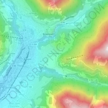
Name: Font Christianne topographic map, elevation, terrain.
Average elevation: 4,718 ft
Minimum elevation: 3,875 ft
Maximum elevation: 6,844 ft
Make a donation
Gear up for your next adventure:
As an Amazon Associate, this site earns from qualifying purchases at no extra cost to you.
Other topographic maps
Click on a map to view its topography, its elevation and its terrain.
Fort des Têtes
France > Provence-Alpes-Côte d'Azur > Hautes-Alpes > Briançon
Average elevation: 4,678 ft
Fort de l'Infernet
France > Provence-Alpes-Côte d'Azur > Hautes-Alpes > Briançon
Il est construit à 2 377 m d'altitude. Ce fort a pour vocation de fermer la frontière avec l'Italie en commandant à distance la vallée de la Durance, menant à Briançon.
Average elevation: 6,345 ft