
Steinfeld topographic map
Click on the map to display elevation.
Steinfeld
Anstois | Benenberg | Diefenbach | Dottel | Frohnrath | Gillenberg | Golbach | Kall | Keldenich | Krekel | Rinnen | Roder | Rüth | Scheven | Sistig | Sötenich | Steinfeld | Steinfelderheistert | Straßbüsch | Urft | Wahlen | Wallenthal | Wallenthalerhöhe
About this map
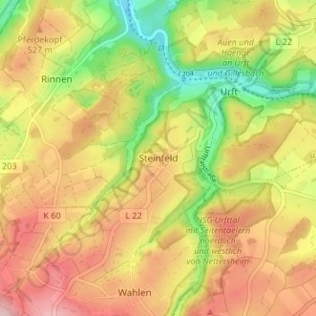
Name: Steinfeld topographic map, elevation, terrain.
Average elevation: 1,617 ft
Minimum elevation: 1,280 ft
Maximum elevation: 1,909 ft
Other topographic maps
Click on a map to view its topography, its elevation and its terrain.
Sistiger Heide
Deutschland > Nordrhein-Westfalen > Kreis Euskirchen > Kall > Benenberg
Average elevation: 1,870 ft