Geolocate

Pinang topographic map

Click on the map to display elevation.

About this map

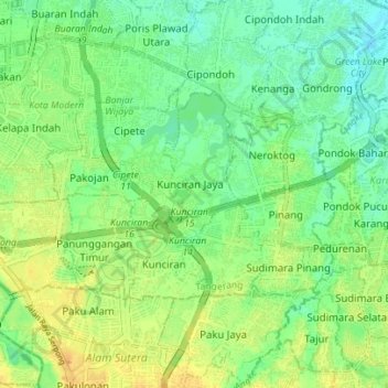
Name: Pinang topographic map, elevation, terrain.

Location: Pinang, Tangerang, Banten, Java, Indonesia (-6.23188 106.62742 -6.19382 106.69711)

Average elevation: 62 ft

Minimum elevation: 20 ft

Maximum elevation: 108 ft

Other topographic maps

Click on a map to view its topography, its elevation and its terrain.

East Asia

Indonesia > Banten > Tangerang

Average elevation: 39 ft

West Europe

Indonesia > Banten > Tangerang

Average elevation: 30 ft

East Asia

Indonesia > Banten > Tangerang

Average elevation: 39 ft

Gear up for your next adventure:

🎒Day Hiking Backpack - Lightweight backpack perfect for day trips and outdoor adventures
🎒Waterproof Dry Bags - Keep your electronics and maps dry inside your pack
🌡️Handheld Weather Meters - Measure wind, temp, and pressure for safe mountain travel
🎒Hydration Pack - Hands‑free water reservoir for long hikes
🧭Outdoor Navigation Book - Learn advanced navigation skills

As an Amazon Associate, this site earns from qualifying purchases at no extra cost to you.