
Thank you for supporting this site ❤️
Make a donation
Make a donation
Gear up for your next adventure:
As an Amazon Associate, this site earns from qualifying purchases at no extra cost to you.
La Navata topographic map
Click on the map to display elevation.
Thank you for supporting this site ❤️
Make a donation
Make a donation
Gear up for your next adventure:
As an Amazon Associate, this site earns from qualifying purchases at no extra cost to you.
About this map
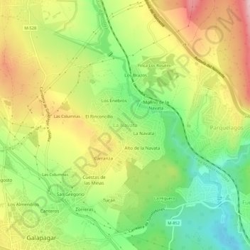
Name: La Navata topographic map, elevation, terrain.
Location: La Navata, Galapagar, Comunidad de Madrid, 28420, España (40.57548 -4.00612 40.61548 -3.96612)
Average elevation: 2,867 ft
Minimum elevation: 2,539 ft
Maximum elevation: 3,245 ft
Thank you for supporting this site ❤️
Make a donation
Make a donation
Gear up for your next adventure:
As an Amazon Associate, this site earns from qualifying purchases at no extra cost to you.
Other topographic maps
Click on a map to view its topography, its elevation and its terrain.
Monte Público Granja y Molino de la Hoz
España > Comunidad de Madrid > Galapagar
Average elevation: 2,178 ft